Arsteca.net
Juxtaposed Syracuse without I-81
Juxtaposed images of Syracuse today vs the proposed true street-grid solution. To understand the images, please read first the i81_DEIS_comments_moneti.pdf.
The model images derive from a large 3D computer model of Syracuse. The model is incomplete. But it should help people visualize what a true street-grid solution (removal of I-81) can do for the city.
The modeling was initially done to measure accurately and verify the redesign of I-690, including height, width, ramps distance from one another; and headroom of ramp under the viaduct. That effort extended to street design and determining the development potential of newly available space. The yellow buildings indicate potential new construction. There are also some new rendered buildings added (if you don't recognize it, it's new).
The core parts of this design are:
- The elimination of both northern and southern section of I-81 within the city, which makes possible better use of the street-grid for the dispersal of traffic, and will stimulate substantial new development both north and south of I-690. I-81 "local" highway spur will still carry traffic to the city limits.
- A series of revised I-690 on/off ramps (at West St, Clinton St, Almond St, and Crouse Ave);
- "Viaduct of the Arts", an I-690 rebuild to include an arcaded structure in select areas with a shop under each arch (perhaps 100 shops total). It mimics the very successful Viaduc des Arts in Paris;
- New Almond Blvd;
- Revised West St;
- 2-way Harrison St and Adams St;
- New "Central Park" replaces the downtown spaghetti junction;
- Erie Blvd (within the city) transformed into a East-West pedestrian/bicycle/transit oriented way;
- New "Oswego St" (replaces I-81 between I-81 and Hiawatha Blvd) transformed into a pedestrian/bicycle/transit oriented way;
- Revised connections to I-81 North spur, Onondaga Lake Pkwy, and Old Liverpool Rd;
- Visualizing northern traffic flowing down multiple North Side streets;
- Entrance to Franklin Square transformed into mixed-use development and plaza;
- Some examples of important intersections converted to roundabouts.
- Over $4 Billion in new development will be stimulated with a well-designed street-grid solution that includes local urban design and planning leadership, along with a transit oriented development plan. $2 Billion in federal and state money can upgrade a lot of roads and intersections and build major new public transit infrastructure.
A revised I-81 south of University Hill to the I-81/I-481 interchange is not yet included. It presumes a 4-lane road brought down to grade (removal of the berm section) with roundabouts at Colvin St, Brighton Ave, and a couple other places. This stretch of road will continue to be highway-like at first—until demand for development arises.
Renderings Compared (click and drag slider using mouse)
1. Erie Blvd at State St with new "Central Park" or "Canal Park".
In the model, the street design is undefined. However, Erie Blvd is already interrupted downtown and makes for a poor cross town street. By rehabilitating Water St, Washington St, and Canal St to take existing Erie Blvd traffic, Erie Blvd could be dedicated to a public-transit/bicycle/pedestrian way, the "Erie Promenade". As an option, it could open initially as a slower 2-lane street (discouraging thru-traffic) until development reaches a point where there is strong demand for a purely transit/pedestrian oriented way. Constructing a streetcar line will help spur redevelopment of the street.


2. Revised Almond St from below Adams St to I-690 Junction.
Not a big boulevard. Just a 4-lane city street with street parking and optional bike lane. Several roundabouts, including an "Underpass roundabout" junction at I-690 will make this street efficient and pleasant to drive. Syracuse Housing Authority is already planning the redevelopment of their properties (lower left) into mixed-use, mid-rise development.


3. Closer view of Almond St between Genesee St and I-690.
The junction at I-690 is a full junction. Eliminating the "spaghetti junction" provides a large amount of newly developable land, enough to create a whole new neighborhood.

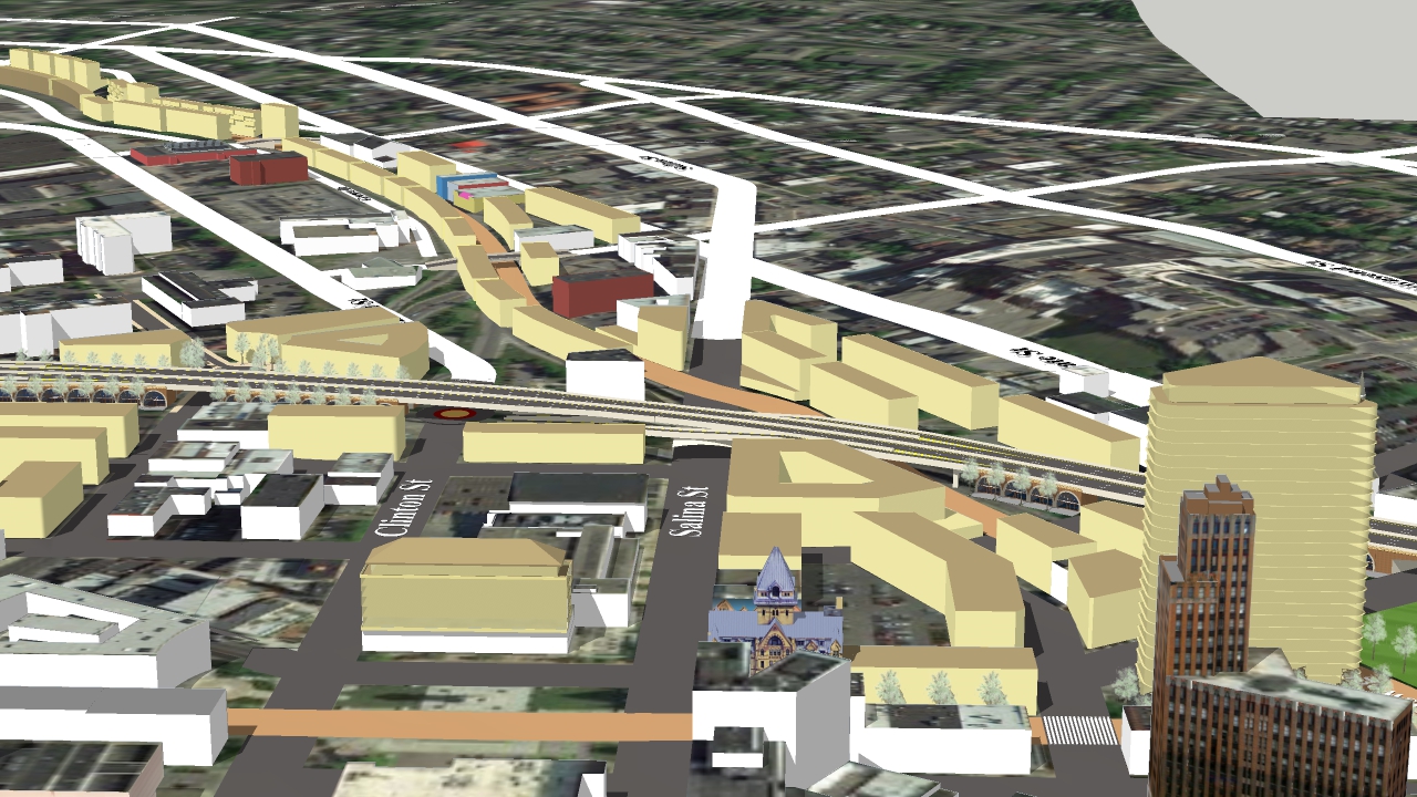
4. Closer view of Almond St near Adams St.
Eliminating I-81 provides space for a large street plus a new row of buildings on the west side (Note: images poorly aligned). Shown at right is the new planned "Nappi Longevity Institute". At left is a new example residential building, and further down a potential new iconic office building. Yellow buildings represent additional infill development.

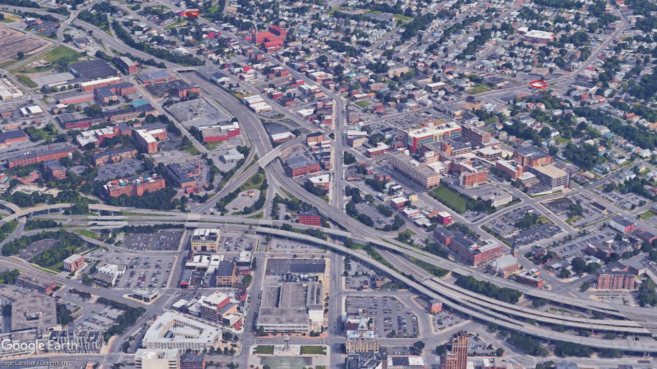
5. A view of a new half junction at I-690 and Clinton St.
S Clinton and N Clinton are reconnected. The "underpass roundabout" junction includes an eastbound onramp and westbound offramp. This allows northern traffic destined east of downtown to use I-690 as a "land bridge" to skip over the downtown area. This is part of the "Two Boulevards and a Bridge" concept—the two boulevards being Clinton St and Almond St.
[Note: Need better image.]
6. A view of revised West St junctions at Genesee St and I-690.
The I690 junction is converted to an "underpass roundabout", a Fast Compact Urban Interchange. Ignore the still visible old ramps which would be replaced with greenspace or new development. West St now connects to Evans St. And notice how the entrance to Franklin Square can now become an attractive plaza.


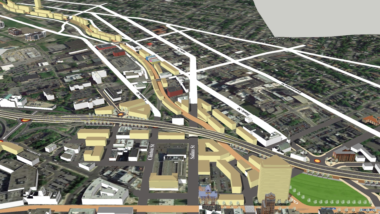
7. A view of northern I-81 path converted to a street with new development.
Ideally, this would become a North/South pedestrian/bicycle/public transit oriented way, the "Oswego Promenade". It is the path of the old Oswego Canal. The white streets represent the main northside streets that will distribute I-81 traffic into the city (Clinton St, 'Oswego St', Salina St, State St, Townsend St, Catherine St, Lodi St, N Crouse Ave), and there is also Hiawatha St, Bear St, Solar St, N Geddes St.
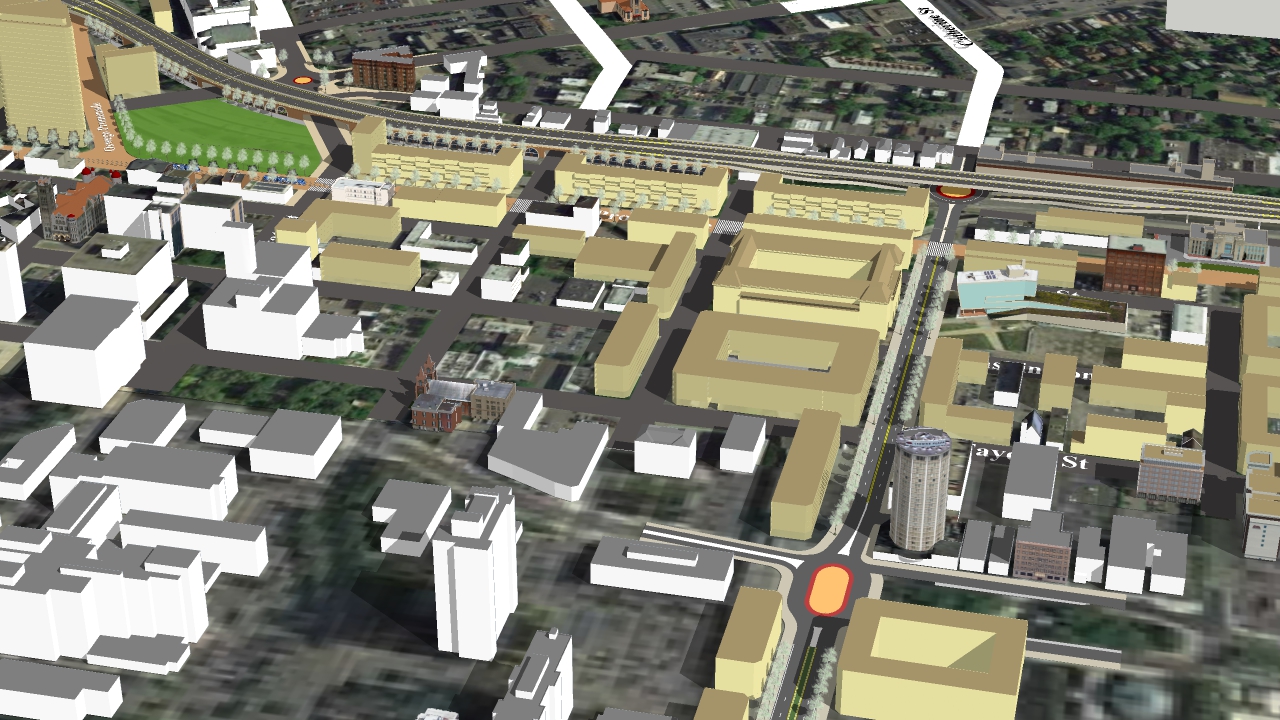
8. A view of revised I-690 between downtown and Lodi St.
Yellow buildings represent new development stimulated by a revised Erie Blvd, extended Canal St, upgraded Water and Fayette St, and reconnected Washington St. This is why Erie Blvd can easily be dedicated as a pedestrian/bicycle/public transit oriented way, which would also create an aesthetically ideal, historically accurate, and commercially successful Canalway Trail through Syracuse.


9. New half junction at Crouse Ave.
This "underpass roundabout" junction includes an eastbound onramp and westbound offramp. It provides easterly traffic access to University Hill and hospitals from the north, greatly reducing traffic that would otherwise accumulate at Almond and Adams St. In the plan, Crouse Ave returns to 2-way traffic. A half-junction here is all that is needed and provides the required distance between Crouse Ave and Almond St ramps.


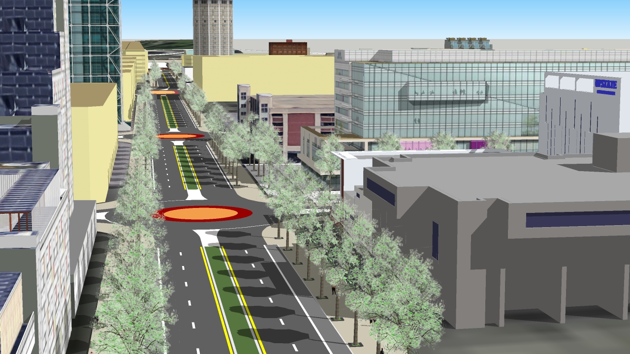
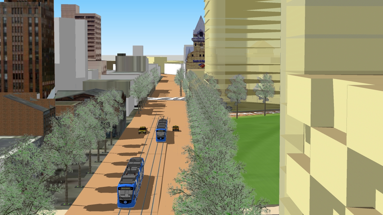
10. Erie Blvd approaching the Canal Museum, with "Central Park" at right.
The street design is yet to be determined. However, a streetcar line is highly desirable. Together with zoning for mixed use development, the new Erie Blvd, or "Erie Way"?, or "Erie Promenade"?, will become the premier address for both residents and businesses, and the ideal path for the Canalway Trail.

11. Intersection of "Erie Promenade" and "Oswego Promenade" at the new "Central Park" (or "Canal Park").
Though it may not appear so from this image, the park is nearly 4X the size of Clinton Square. It will be a great place for concerts and festivals. Features of the park (seating, covered areas, fountain, plantings, play area, bandstand, etc.) are yet to be determined.


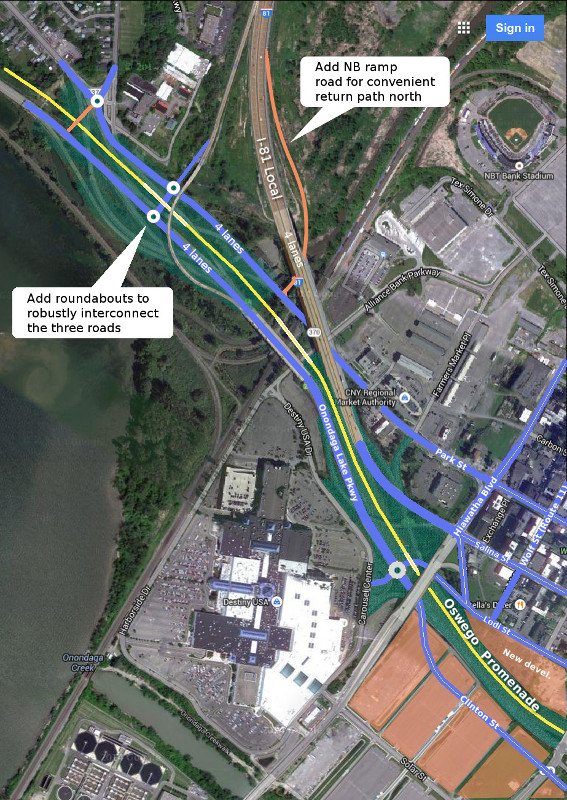
12. Reconfigured (greatly simplified) I-81 "local", Onondaga Lake Parkway (OLP), and Park St connections.
- I-81 "local" reduces to 4 lanes and connects to Salina St (much like I-81 ramps do now).
- OLP connects to N Clinton St via a roundabout that also connects Destiny Mall and Lodi St.
- The existing I-81 Exit 23A viaduct remains as is, connecting to OLP southbound. However a branch off this exit connects to Park St. Also, a new northbound I-81 onramp from Park St is added. This makes it possible for I-81 traffic from the north to access Destiny Mall, the Farmer's Market, the stadium, and the Regional Transportation Center without needing to access Hiawatha Blvd either coming or going. This will significantly lower Hiawatha Blvd traffic even compared to today.
- The overall connection scheme allows traffic to flow easily among the three main routes into the city according to need and for traffic dispersal. It also allows direct access toward Liverpool from the I-81 exit 23A.
- The "Oswego Promenade" (yellow line) can optionally be extended all the way to Liverpool as a bike/pedestrian/running path. A bus or streetcar extension could also be added.
- The short link at Old Liverpool Rd roundabout to OLP is optional, though it should exist at least as a bike/pedestrian path.
Although it may at first appear that virtually all I-81 traffic will default onto Salina St, this is not the case. In the broader design, the I-690 ramps are accessed from Clinton St. Therefore all the traffic headed for I-690 will take Clinton St into the city. This includes traffic destined just east of downtown towards University Hill and the hospitals, who may find hopping on I-690 to "bridge" over downtown to Almond St Exit advantageous. In this way, upper Salina St and Clinton St will be equally loaded. From there, traffic will disperse along multiple additional routes as it moves deeper into the city: Hiawatha Blvd, Genant Dr, Lodi St, State St, Townsend St, McBride St, Catherine St. All of which would be upgraded.